The emergence of drones in different business and scientific sectors is undeniable today. It is a fact that, during the last years, agriculture has ceased to look only from the ground point of view to start observing crops from the sky. This is demonstrated by the rising organizations of specific events where people discuss about drone applications in agriculture, also by specific lines of research related with drones and crop monitoring, scientific publications, and the rising commercial application of high-resolution remote sensing with drones as a tool for farm management. Although the legal restrictions imposed by the relevant Administration will play an important role in the speed of implementation of this technology for civilian use, in agriculture, there is a further limiting factor to be considered. What is the true benefit to a farmer? The answer lies not only in the image (however good it is) but in the information which is hidden under it.
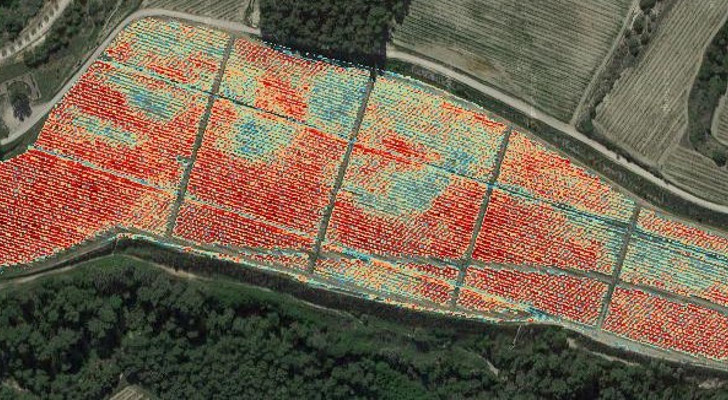
If we fail to decipher, interpret and evaluate the information contained in each of the photographed fields to generate useful management recommendations to farmers, the potential of drones for agriculture may not last long. The market that we have today is still growing, with continuous evolution and a growing interest in this remote sensing tool with drones. Therefore, our main task is to disseminate widely the emerging real success stories. There are already companies that offer reliable agronomic advices based on maps generated from high resolution images, which are taken from the air by various models of drones (multicopters and fixed wings). The main demands of the sector focus on maps that describe the differences in the crop growth and the status of crop stress, and show the variability on a global scale and define its structure, all with pixel size below 10 cm. The best known maps are the ones that relate the chlorophyll absorption bands ( 488 and 660-700 nm ) and the near-infrared spectral region ( 730-900 nm ). With these spectral bands, we can calculate the indices such as the NDVI or the PCD, which are simple calculations and interpretations, or some more complex indices like the TCARI/OSAVI. These vegetation indices are correlated with physiological aspects of vegetation like photosynthetic activity, which is chlorophyll content or plant stress, and structural aspects of the crop like Leaf Area Index (LAI), leaf density or biomass content among others. The generated maps are used to define the homogeneous growth areas in the parcel or homogeneous management units, or in cases of very variable parcels, to decide the management actions that lead to a homogenization of crops (fertilization, pruning, irrigation, etc.). The future points to automatic pest detection systems in crops, which is a service widely demanded by farmers from various sectors. We must say that the direct detection of pests is currently in the process of scientific development. And although the process has been made in this regard in various crops such as vines and citrus, neither a detection system nor a disease mapping can be provided yet. Conclusions from scientific research performed highlight the need of high-resolution images, the suitability of drones for this purpose, the need of sophisticated sensors and systems for complex analysis to reach acceptable detection levels. It is the responsibility of the technical advisors, data analysts, and drone operators to ensure the proper dissemination of this technology, to avoid creating false expectations among the potential customers and to maintain the growing and sustained implementation of remote sensing with drones in modern agriculture.